Featured Post

9th August 2016 Current Affairs Questions and Answers

9th August 2016 Current Affairs MCQs, Quiz, Questions : Current Affairs for August 2016 ,  Daily Multiple Choice Questions (MCQs) for In...

Showing posts with label Geography. Show all posts

Nitin Gadkari flags off cargo movement on Pandu-Dhubri route in Brahmaputra river

Nitin Gadkari flags off cargo movement on Pandu-Dhubri route in Brahmaputra river on 29th December 2017. This largely untapped sector has great potential, and has plenty of cost advantages. Stating that modern and well-equipped river ports will be established along the banks of the river, the minister said transportation of cargo through the National Waterway 2 - from Pandu in Guwahati to Dhubri along the Assam-Bengal border will reduce logistics cost and save 300 km road travel.
Waterways are regarded as natural transport routes. India has around 14500 kms of waterways which were for long, untapped. It was only under Prime Minister Modi's insistent patronage  that waterways became a significnt part of the govt's transport agenda. As of now, there are 6 interstate waterways in India

  • 1st from Allahabad to Haldia
  • 2nd from Sadiya to Dhubri
  • 3rd from Kollam to Kottapuram
  • 4th from Kakinada to Marakkanam
  • 5th from Talchar to Dhamra
  • 6th from Lakhipur to Bhhanga

Turtle Sanctuary, Allahabad

Turtle Sanctuary, Allahabad:

  • Turtle sanctuary in Allahabad along with a River Biodiversity Park at Sangam have been approved on 4th October 2017 under Namami Gange programme in order to protect the rich aquatic biodiversity of river Ganga from escalating anthropogenic pressures.
  • The project at an estimated cost of Rs 1.34 crore would include development of River Biodiversity Park at Sangam (confluence of Ganga, Yamuna and mythical Sarasvati), establishment of a Turtle Rearing Centre (Permanent nursery at Triveni Pushp and makeshift annual hatcheries) and awareness about the importance of river Ganga and imperativeness of its conservation has been approved. 
  • The task of dissipating knowledge about river Ganga will be taken up ardently in this project, which is 100% centrally funded. 
  • The sustenance of more than 2000 aquatic species including threatened gharials, dolphins and turtles in river Ganga exemplifies the rich biodiversity of this lifeline to over 40 per cent of the country’s population. 
  • Rivers Ganga and Yamuna at Allahabad are home to some of the most endangered fauna like turtles (Batagur kachuga, Batagur dhongoka, Nilssonia gangetica, Chitra indica, Hardella thurjii etc.), the National Aquatic Animal - Gangetic dolphin (Platanista gangetica), the Gharial (Gavialis gangeticus) and numerous migratory and resident birds. 

How Sardar Sarovar Dam is second largest dam in world?

How Sardar Sarovar Dam is second largest dam in world? 
Prime Minister Narendra Modi on 17th September inaugurated and dedicated the Sardar Sarovar Dam project on the Narmada river to the nation, during his visit to Gujarat. The project is expected to benefit the people of Gujarat, Rajasthan, Madhya Pradesh and Maharashtra through irrigation facilities and increased electricity generation.  It is claimed to be second largest dam in the world.
  • Now comes the Question How Sardar Sarovar Dam is second largest dam in the world?
Let's take a look at Top 3 Dams by Height, Length, Volume, Capacity, Power Generation and other figures in world.
  • World Largest Dam by Structure Height(Meter)
    1. Nurek Dam, Tajikistan = 300 M
    2. Oroville Dam, United States = 230 M
    3. San Roque Dam, Philippines = 210M
    4. Kölnbrein Dam, Austria = 200 M
    5. W. A. C. Bennett Dam, Canada = 186 M
    • Sardar Sarovar Dam, India = 138 M
  • World Largest Dam by Structure volume [106 m3]
    1. Tarbela Dam,  Pakistan = 153
    2. Fort Peck Dam, United States = 96
    3. Atatürk Dam, Turkey = 84.5
    4. Houtribdijk, Netherlands = 78
    5. Oahe Dam, United States = 70.3
  • World Largest Dam by Reservoir volume [10*9 m3]
    1. Aswan Dam, Egypt = 169
    2. Guri Dam, Venezuela = 135
    3. Samara Dam, Russia = 57.3
    4. Atatürk Dam, Turkey = 48.7
    5. Three Gorges Dam, China = 39.3
These are 3 Main figure to decide the Largest Dam in world, while  Sardar Sarovar Dam in not among top 5 or even top 10 list. We have search most of authentic websites like PIB, DD News, Wikipedia and other authentic websites. We found on just one News topic on ZeeNews owned website without much data on it as "The Sardar Sarovar Dam is the second largest in terms of the volume of concrete used in building the dam". 
All readers are requested to share authentic source How Sardar Sarovar Dam is second largest dam in world, as this questions looks important for upcoming competitive examination?

Second ozone hole was detected over

Second ozone hole was detected over?
A. Antarctica
B. Artica
C. Sweden
D. Northern Hamisphere
Answer: B (This question was Asked in SSC JE Exam 2015, However we could have chosen Tibet as 2nd Hole as it was discovered in year 2006 but as per Options available B, Artic should be correct Answer. 
  • Ozone, a form of oxygen, acts as a high-altitude atmospheric screen against cancer-causing ultraviolet light. Ozone depletion describes two distinct but related phenomena observed since the late 1970s: a steady decline of about four percent in the total amount of ozone in Earth's stratosphere (the ozone layer), and a much larger springtime decrease in stratospheric ozone around Earth's polar regions. The latter phenomenon is referred to as the ozone hole.
  • The main source of these halogen atoms in the stratosphere is photodissociation of man-made halocarbon refrigerants, solvents, propellants, and foam-blowing agents (chlorofluorocarbon (CFCs), HCFCs, freons, halons). These compounds are transported into the stratosphere by winds after being emitted at the surface. Both types of ozone depletion were observed to increase as emissions of halocarbons increased. CFCs and other contributory substances are referred to as ozone-depleting substances (ODS). 
  • Ozone Layer Holes are:
    • Antarctic Ozone Hole: Antarctic ozone hole has been one of the major environmental issues of the past few decades. Its discovery in the mid 1980s was completely unexpected and prompted intense research activities to determine its cause.  
    • Arctic Ozone HoleAn ozone hole five times the size of California opened over the Arctic in year 2011, matching ozone loss over Antarctica.  There are several reasons as to why the arctic ozone hole is less prominent in comparison to the antarctic hole. Firstly, Polar Vortex, a natural circulation of wind that isolates Antarctica from rest of the world during winter is less developed over arctic. Secondly,  stratospheric temperatures at Arctic, are not as low as in the Antarctic. This is a lucky proposition because formation of even a moderate ozone hole above the Arctic region can give cause for considerable concern due to the greater populations in the higher latitudes of the Northern Hemisphere. Thirdly, Earth’s magnetic field directs more positively charged solar wind particles to Earth’s south pole. 
    • Tibet ozone holeAs winters that are colder are more affected, at times there is an ozone hole over Tibet. In 2006, a 2.5 million square kilometer ozone hole was detected over Tibet. Also again in 2011 an ozone hole appeared over mountainous regions of Tibet, Xinjiang, Qinghai and the Hindu Kush, along with an unprecedented hole over the Arctic, though the Tibet one is far less intense than the ones over the Arctic or Antarctic.

Rocks Types: Igneous, Sedimentary and Metamorphic rocks

Types of Rocks: Earth’s crust is made up of various types of rocks. Any natural mass of mineral matter that makes up the earth’s crust is called a rock. Rocks can be of different colour, size and texture. There are three major types of rocks: igneous rocks, sedimentary rocks and metamorphic rocks.

  1. Igneous Rocks: When the molten magma cools, it becomes solid. Rocks thus formed are called igneous rocks. They are also called primary rocks. There are two types of igneous rocks: intrusive rocks and extrusive rocks.
    • Intrusive Rocks: When molten lava comes on the earth’s surface, it rapidly cools down and becomes solid. Rocks formed in such a way on the crust are called extrusive igneous rocks. They have a very fine grained structure. For example, basalt. The Deccan plateau is made up of basalt. 
    • Extrusive Rocks: Sometimes the molten magma cools down deep inside the earth’s crust. Solid rocks so formed are called intrusive igneous rocks. Since they cool down slowly they form large grains. Granite is an example of such a rock. 
  2. Sedimentary Rocks: Rocks roll down, crack, and hit each other and are broken down into small fragments. These smaller particles are called sediments. These sediments are transported and deposited by wind, water, etc. These loose sediments are compressed and hardened to form layers of rocks. These types of rocks are called sedimentary rocks. For example, sandstone is made from grains of sand. 
  3. Metamorphic rocks: Igneous and sedimentary rocks can change into metamorphic rocks under great heat and pressure. For example, clay changes into slate and limestone into marble.

Barter System

Barter System is a trade in which goods are exchanged without the use of money. This system has been used for centuries and long before money was invented. People exchanged services and goods for other services and goods in return. In ancient times, this system involved people in the same area, however today bartering is global. The value of bartering items can be negotiated with the other party. 
The history of bartering dates all the way back to 6000 BC. Introduced by Mesopotamia tribes, bartering was adopted by Phoenicians. Phoenicians bartered goods to those located in various other cities across oceans. Babylonian's also developed an improved bartering system. Goods were exchanged for food, tea, weapons, and spices. In the Middle Ages, Europeans traveled around the globe to barter crafts and furs in exchange for silks and perfumes. Due to lack of money, bartering became popular in the 1930s during the Great Depression. It was used to obtain food and various other services.

Earth's Atmosphere Layers

Earth's Atmosphere Layers: The Earth's atmosphere is divided into 5 layers. It is thickest near the surface and thins out with height until it eventually merges with space. Moving upward from ground level, these layers are named the troposphere, stratosphere, mesosphere, thermosphere and exosphere. The exosphere gradually fades away into the realm of interplanetary space.

  1. Troposphere: The troposphere starts at the Earth's surface and extends 8 to 14.5 kilometers high. This part of the atmosphere is the most dense. Almost all weather is in this region.
  2. Stratosphere: The stratosphere starts just above the troposphere and extends to 50 kilometers  high. Commercial passenger jets fly in the lower stratosphere, partly because this less-turbulent layer provides a smoother ride. The jet stream flows near the border between the troposphere and the stratosphere. The ozone layer, which absorbs and scatters the solar ultraviolet radiation, is in this layer.
  3. Mesosphere: The mesosphere starts just above the stratosphere and extends to 85 kilometers  high. Most meteors burn up in the mesosphere. Unlike the stratosphere, temperatures once again drop as you rise up through the mesosphere. The coldest temperatures in Earth's atmosphere, about -90° C (-130° F), are found near the top of this layer. 
  4. Thermosphere: The thermosphere starts just above the mesosphere and extends to 600 kilometers high. Aurora and satellites occur in this layer.
  5. Exosphere: The atmosphere merges into space in the extremely thin exosphere. This is the upper limit of our atmosphere. The exosphere is the most distant atmospheric region from Earth's surface. In the exosphere, an upward travelling molecule can escape to space (if it is moving fast enough) or be pulled back to Earth by gravity with little probability of colliding with another molecule. The exosphere is a transitional zone between Earth's atmosphere and interplanetary space.

National Green Tribunal (NGT)

National Green Tribunal (NGT)

  • National Green Tribunal has been established on 18.10.2010 under the National Green Tribunal Act 2010 for effective and expeditious disposal of cases relating to environmental protection and conservation of forests and other natural resources including enforcement of any legal right relating to environment and giving relief and compensation for damages to persons and property and for matters connected therewith or incidental thereto. 
  • It is a specialized body equipped with the necessary expertise to handle environmental disputes involving multi-disciplinary issues. 
  • The Tribunal shall not be bound by the procedure laid down under the Code of Civil Procedure, 1908, but shall be guided by principles of natural justice. It draws inspiration from the India's constitutional provision of Article 21, which assures the citizens of India the right to a healthy environment.
  • The Tribunal is mandated to make and endeavour for disposal of applications or appeals finally within 6 months of filing of the same. 
  • On 18 October 2010, Justice Lokeshwar Singh Panta became its first Chairman. Currently it is chaired by Justice Swatanter Kumar since 20 Dec 2012.
  • National Green Tribunal (NGT) is in News recently after green panel said that diesel vehicles which are 15- years-old should be de-registered first and will not get No Objection Certificate (NoC) for plying outside Delhi-NCR.

Earthquake Waves

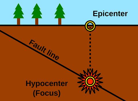
Earthquake in simple words is shaking of the earth. It is a natural event. It is caused due to release of energy, which generates waves that travel in all directions. 
  • The point where the energy is released is called the focus of an earthquake, alternatively, it is called the hypocentre
  • The energy waves travelling in different directions reach the surface. The point on the surface, nearest to the focus, is called epicentre.
  • All natural earthquakes take place in the lithosphere or earth consisting of solid rocks. An instrument called ‘seismograph’ records the waves reaching the surface.
  • The earthquake events are scaled either according to the magnitude or intensity of the shock. The magnitude scale is known as the Richter scale.
Earthquake Waves: There are Three types of Earthquake Waves. They are called P-waves, S-waves and surface waves. 

  1. P-waves or ‘primary waves’ move faster and are the first to arrive at the surface. They travel through gaseous, liquid and solid materials. 
  2. S-waves or secondary waves arrive at the surface with some time lag.  
  3. Surface waves are the last to report on seismograph. These waves are more destructive. They cause displacement of rocks, and hence, the collapse of structures occurs.
Check Geography Notes at Geography of World and India or Notes section of INDIA GK Mobile App. 

Equator passes through which countries ?

Through which one of the following groups of countries does equator pass? (IAS Pre 2006)
A. Brazil, Zambia and Malaysia
B. Columbia, Kenya and Indonesia
C. Brazil, Sudan and Malaysia
D. Venezuela, Ethiopia and Indonesia
Answer: B
Explanation: The equator passes through 13 countries in world. Equator traverses the land of 11 countries and two island nations, though without making a landfall in either. Starting from Ecuador, the Equator passes through following 13 Countries:

  1. Ecuador
  2. Colombia
  3. Brazil
  4. Sao Tome and Principe
  5. Gabon
  6. Republic of The Congo
  7. Democratic Republic of The Congo
  8. Uganda
  9. Kenya
  10. Somalia
  11. Maldives (the equator passes through the territory but not on dry land)
  12. Indonesia
  13. Kiribati (the equator may or may not touch dry land)

Major Achievements of India since Independence

15 Major Achievements of India since Independence: It is not true that India has done nothing and not achieved in past 65 years of Independence Day. Post independence despite not having access to electricity, roads, better education, high level equipment and wealth, India has consistently doled out stalwarts in the fields of science, technology and social reforms.We believed there might be up and down but India achieved many things in last 65 years and here is Major Achievements of India since Independence under various prime ministers of India and people of India.
15 Major Achievements of India since Independence:
1. Creating The Republic: India became an independent nation within the British Commonwealth on 15 August 1947. The Constitution was adopted by the India Constituent Assembly on 26 November 1949, and came into effect on 26 January 1950.

2. Construction of New India with Dams and irrigation Projects.

Bhakra Dam (226 M) is a concrete gravity dam across the Sutlej River in Himachal Pradesh.
3. Heavy Industry in India.
Bombay High is an offshore oilfield by ONGC 162 kilometres off the coast of Mumbai.
4. Panchayat Raj system to Empower Rural India.
Panchayat Raj System was first adopted by the state of Rajsthan in Nagaur district on 2nd Oct 1959
5. Green Revolution is identified with India's being catapulted from a chronically food-short country, with a begging-bowl image, to one which was self-sufficient and which became over time even surplus in food. The change follows the major technological reforms that occurred in Indian agriculture, particularly from the mid-1960s. 
6. India-Pakistan War & Liberating Bangladesh, 1971
December 1971: Lt.Gen. AAK.Niazi (right) of Pakistan signs the surrender documents.
7. Pokharan 1 or 'Smiling Buddha' - India's first nuclear test by Prime Minister Indira Gandhi. Smiling Buddha (Pokhran-I) was the assigned code name of India's first successful nuclear bomb test on 18 May 1974. The bomb was detonated on the army base, Pokhran Test Range (PTR), in Rajasthan by the Indian Army under the supervision of several key army officials.

8. Jawahar Navodaya Vidyalaya, 1985: Jawahar Navodaya Vidyalayas (JNVs) are a system of alternate schools for gifted students in India. There are approximately 600 JNVs across India (one school per district). JNVs are specifically tasked with finding talented children in rural areas of India and providing them with an education equivalent to the best residential school system, without regard to their family's socio-economic condition.
9. Rise of IT industry (1998-2008): Information technology in India is an industry consisting of two major components: IT services and business process outsourcing (BPO). The sector has increased its contribution to India's GDP from 1.2% in 1998 to 7.5% in 2012.
10. Golden quadrilateral and other new highways - Over 40,000 km of highways/expressways added in the past 15 years. The Golden Quadrilateral is a highway network connecting many of the major industrial, agricultural and cultural centres of India. A quadrilateral of sorts is formed by connecting Chennai, Kolkata, Delhi and Mumbai, and hence its name.

11. PMGSY, 2000: Pradhan Mantri Gram Sadak Yojana (PMGSY) is a nationwide plan in India to provide good all-weather road connectivity to unconnected villages.

12. Right to Information (RTI) Act. that has turned thorn in govt flesh. Right to Information Act (RTI) is an Act of the Parliament of India "to provide for setting out the practical regime of right to information for citizens" and replaces the erstwhile Freedom of information Act, 2002.
13. Chandrayaan: Chandrayaan-1 was India's first lunar probe. It was launched by the Indian Space Research Organisation (ISRO) in October 2008, and operated until August 2009. The mission included a lunar orbiter and an impactor.
14. Right to Education Act (RTE): Right of Children to Free and Compulsory Education Act or Right to Education Act (RTE), is an Act of the Parliament of India enacted on 4 August 2009, which describes the modalities of the importance of free and compulsory education for children between 6 and 14 in India under Article 21A of the Indian Constitution.
15. Polio Free India: Ending polio among 1.3 billion people in India is world's greatest health achievement.  World Health Organisation (WHO) South-East Asia Region, home to a quarter of the world’s population, was certified polio-free in March 2014 by an independent commission under the WHO certification process. This is the fourth of six WHO Regions to be certified, marking an important step towards global polio eradication. 

Tropic of Cancer passes through which states of India

Tropic of Cancer passes through which states of India: Tropic of Cancer passes through 8 Indian states: Gujarat, Rajasthan, MP, Chhattisgarh, Jharkhand, West Bengal, Tripura and Mizoram. Tropic of Cancer, also referred to as the Northern Tropic, is the most northerly circle of latitude on the Earth at which the Sun may appear directly overhead at its culmination. This event occurs once per year, at the time of the Northern solstice, when the Northern Hemisphere is tilted toward the Sun to its maximum extent. It lies at 23° North of the Equator.
 
Trick to Remember 8 States: MiRa's JCB at GMT 
Mi- Mizoram
Ra- Rajasthan
J- Jharkand
C- Chattisgarh
B- Bengal
G- Gujarat
M- Madhya Pradesh
T- Tripura

Q. Which state of India is located in the North of tropic of Cancer ? (Asked in Rajasthan PSC 2015)A. Mizoram
B. Jharkhand
C. Tripura
D. Manipur
Answer: D

Sanjeev Balyan launches KISAN Project and Hailstorm App

Minister of State for Agriculture & Farmers’ Welfare, Dr. Sanjeev Kumar Balyan today launched KISAN Project [C(K)rop Insurance using Space technology And geoiNformatics]  of Department of Agriculture, Cooperation & FW, Ministry of Agriculture and FW.  The project envisages use of Space Technology and geoinformatics (GIS, GPS and Smartphone) technology along with high resolution data from UAV/Drone based imaging for improvement in yield estimation and better planning of Crop Cutting Experiments (CCEs), needed for crop insurance programme. The Pilot Study is proposed to be launched in one District each of Haryana, Karnataka, Madhya Pradesh and Maharashtra during Kharif season of 2015 and two Districts each of these States during Rabi season of 2015-16.  
Dr. Balyan also launched an Android App. Designed by ISRO (National Remote Sensing Centre, Hyderabad).  This App will help real time data collection about hailstorm occurrences along with photographs and geographical coordinates (longitude and latitude).  The Minister informed that App will help Government to get real time data about the Hailstorms which will be collected through the Agriculture Department officials of different States.  This will support in deciding the crop loss more objectively and in a very fast manner. 

Sustainable Sugarcane Initiative

Sustainable Sugarcane Initiative (SSI) aims at providing practical options to the farmers in improving the productivity of land, water and labour, all at the same time.  SSI is also expected to reduce the overall pressure on water resources and contribute to recovery of ecosystems. Sustainable Sugarcane Initiative is an innovative method of sugarcane production using less seeds, less water and optimum utilization of fertilizers and land to achieve more yields.
The major principles that govern SSI
  • Raising nursery in portrays using single budded chips
  • Transplanting young seedlings (25-35 days old)
  • Maintaining wider spacing (5x2 feet) in the main field
  • Providing sufficient moisture through efficient water management technologies viz.,drip fertigation (sub or sub surface)Encouraging organic method of nutrient and plant protection measures
  • Practicing intercropping with effective utilization of land
Overall benefits
  • Improved water use efficiency
  • Optimum use of fertilizers favour balanced availability of nutrients
  • Better aeration and more penetration of sunlight favours higher sugar content
  • Reduced cost of cultivation and increased returns  through intercropping

Montreux Record and Ramsar Convention on Wetland

Montreux Record and Ramsar Convention on Wetland: Ramsar Convention on Wetland was held in Ramsar, Iran, in 1971, is an intergovernmental treaty which provides the framework for national action and international  cooperation for the conservation and wise use of wetlands and their resources. There are presently 158 Contracting Parties to the Convention, with 1758 wetland  sites, totaling 161 million hectares, designated for inclusion in the Ramsar List of Wetlands of International Importance. Ramsar Convention is the only global environment treaty dealing with a particular ecosystem. The Ramsar Convention on Wetlands was developed as a means to call international attention to the rate at which wetland habitats were disappearing, in part due to a lack of understanding of their important functions, values, goods and services. Governments that join the  Convention are expressing their willingness to make a commitment to helping to reverse that history of wetland loss and degradation. The text of the Convention  and other details can be accessed on Ramsar Convention's website ( www.ramsar.org). World Wetlands Day which is celebrated each year on 2 February, marks the date of the adoption of the Convention on Wetlands on 2 February 1971, in the Iranian
Major obligations of countries which are party to the Convention are:
  • Designate wetlands for inclusion in the List of Wetlands of International Importance.
  • Promote, as far as possible, the wise use of wetlands in their territory.
  • Promote international cooperation especially with regard to transboundary wetlands, shared water systems, and shared species.
  • Create wetland reserves.
Montreux Record
  • Montreux Record under the Convention is a register of wetland sites on the List of Wetlands of International Importance where changes in ecological character have occurred, are occurring, or are likely to occur as a result of technological developments, pollution or other human interference. It is maintained as part of the Ramsar List.
  • The Montreux Record was established by Recommendation 4.8 of the Conference of the Contracting Parties (1990). 
  • Resolution 5.4 of the Conference (1993) determined that the Montreux Record should be employed to identify priority sites for positive national and international conservation attention. Sites may be added to and removed from the Record only with the approval of the Contracting Parties in which they lie. 
  • Convention on Wetlands came into force for India on 1 February 1982. 
  • India presently has 26 sites designated as Wetlands of International Importance, with a surface area of 689,131 hectares.
  • Total 26 Sites are:
    1. Ashtamudi Wetland, (Kerala)
    2. Bhitarkanika Mangroves, (Orissa)
    3. Bhoj Wetland, (Madhya Pradesh)
    4. Chandra Taal, (Himachal Pradesh)
    5. Chilika Lake, (Orissa)
    6. Deepor Beel, (Assam)
    7. East Calcutta Wetlands, (West Bengal)
    8. Harike Wetland, (Punjab)
    9. Hokera Wetland, (Jammu and Kashmir)
    10. Kanjli Wetland, (Punjab)
    11. Keoladeo National Park, (Rajasthan)
    12. Kolleru Lake, (Andhra Pradesh)
    13. Loktak Lake, (Manipur)
    14. Nalsarovar Bird Sanctuary, (Gujarat)
    15. Point Calimere Wildlife and Bird Sanctuary, (Tamil Nadu)
    16. Pong Dam Lake, (Himachal Pradesh)
    17. Renuka Lake, (Himachal Pradesh)
    18. Ropar_Wetland, (Punjab)
    19. Rudrasagar Lake, (Tripura)
    20. Sambhar Lake, (Rajasthan)
    21. Sasthamkotta Lake, (Kerala)
    22. Surinsar-Mansar Lakes, (Jammu and Kashmir)
    23. Tsomoriri, (Jammu and Kashmir)
    24. Upper Ganga River (Brijghat to Narora Stretch), (Uttar Pradesh)
    25. Vembanad-Kol Wetland, (Kerala)
    26. Wular Lake, (Jammu and Kashmir)

New Moore Island

New Moore Island or South Talpatti ( Known in Bangladesh)  was a small uninhabited offshore sandbar landform in the Bay of Bengal, off the coast of the Ganges-Brahmaputra Delta region. It emerged in the Bay of Bengal in the aftermath of the Bhola cyclone in 1970, and disappeared at some later point. For nearly 30 years, India and Bangladesh have argued over control of a tiny rock island in the Bay of Bengal but later in 2010 the rising sea levels have resolved the dispute for them: the island's gone. New Moore Island, in the Sunderbans, has been completely submerged, Its disappearance has been confirmed by satellite imagery and sea patrols.  Scientists at the School of Oceanographic Studies have noted an alarming increase in the rate at which sea levels have risen over the past decade in the Bay of Bengal. Although the island was uninhabited and there were no permanent settlements or stations located on it, both India and Bangladesh claimed sovereignty over it because of speculation over the existence of oil and natural gas in the region. 
The Resolution:  In Permanent Court of Arbitration (PAC) the dispute was settled in July 2014 by a final verdit not open to appeal and in favour of Bangladesh. The Permanent Court of Arbitration (PCA) verdict awarded Bangladesh with 19,467 km2 out of 25,000 km2 disputed area with India in the Bay of Bengal. However New Moore Island (or South Talpatti Island to the Bangladesh) has fallen in India`s part of the Bay of Bengal. In 2014, External affairs ministry spokesperson Syed Akbaruddin said "We believe that the settlement of the maritime boundary will further enhance mutual understanding and goodwill between India and Bangladesh by bringing to closure a long pending issue. This paves the way for the economic development of this part of the Bay of Bengal, which will be beneficial to both countries," the spokesperson added. Bangladesh has also welcomed the ruling. According to reports from Dhaka, Bangladesh`s Foreign Minister A.H. Mahmood Ali said in a press briefing that it was a "victory for both sides".

North America's tallest peak Mt. McKinley renamed Denali

Mount McKinley, the 20,237-foot mountain and the tallest in North America which was named after 25th U.S. president, William McKinley, Obama administration renames Mount McKinley to Denali. The mountain, which sits in the 6 million-acre Denali national park, has been known as Denali in Alaska since 1975. Under an order signed by Interior Secretary Sally Jewell, the Denali name will also take effect for all federal usage and, therefore, on all official maps.
Denali, meaning “the great one” in the Athabaskan language of Alaska natives, was the original name of the mountain. But when European Americans discovered it in the 19th century, they renamed it Densmore’s Mountain and, later, Mount McKinley in an effort to boost the presidential candidacy of Republican William McKinley.

Living Root Bridges

Living Root Bridges are found in Meghalaya. The local people train the roots of living trees into robust bridges across the streams. As the time passes, these bridges become stronger. These unique 'living root bridges' are found in North East state Meghalaya of India. The pliable tree roots are trained to grow through betel tree trunks which are placed across the gap, until the figs' roots take root on the other side. Sticks, stones, and other inclusions are placed with the growing bridge.This process can take up to 15 years to complete. There are specimens spanning over 100 feet. The useful lifespan of the bridges, once complete, is thought to be 500–600 years. They are naturally self-renewing and self-strengthening as the component roots grow thicker.
The Living root bridges, some of which are over a hundred feet long, take ten to fifteen years to become fully functional, but they're extraordinarily strong — strong enough that some of them can support the weight of 50 or more people at a time. In fact, because they are alive and still growing, the bridges actually gain strength over time — and some of the ancient root bridges used daily by the people of the villages around Cherrapunji may be well over 500 years old.

Forest Carbon Partnership Facility

Forest Carbon Partnership Facility  is a global partnership of governments, businesses, civil society, and Indigenous Peoples focused on reducing emissions from deforestation and forest degradation, forest carbon stock conservation, the sustainable management of forests, and the enhancement of forest carbon stocks in developing countries (activities commonly referred to as REDD+).
The four strategic objectives of the FCPF:
  1. To assist countries in their REDD+ efforts by providing them with financial and technical assistance in building their capacity to benefit from possible future systems of positive incentives for REDD+.
  2. To pilot a performance-based payment system for REDD+ activities, with a view to ensuring equitable benefit sharing and promoting future large-scale positive incentives for REDD+.
  3. Within the approach to REDD+, to test ways to sustain or enhance livelihoods of local communities and to conserve biodiversity.
  4. To disseminate broadly the knowledge gained in the development of the Facility and the implementation of Readiness Preparation Proposals (RPPs) and Emission Reductions Programs (ERPs).
Question Asked USPC CSE 2015- GS Exam Paper:
With reference to 'Forest Carbon Partnership Facility', which of the following statements is/ are correct?
1. It is a global partnership of governments, businesses, civil society and indigenous peoples.
2. It provides financial aid to universities, individual scientists and institutions involved in scientific forestry research to develop eco-friendly and climate adaptation technologies for sustainable forest management.
3. It assists the countries in their 'REDD+ (Reducing Emissions from Deforestation and Forest Degradation+)' efforts by providing them with financial and technical assistance.
Select the correct answer using the code given below.
A. 1 only
B. 2 and 3 only
C. 1 and 3 only
D. 1, 2 and 3
Answer. D

Great Himalayan National Park in UNESCO Heritage site list, Now Total 32 Sites from India

Great Himalayan National Park inscribed as a World Heritage Site. Great Himalayan National Park Conservation Area, a rich biodiversity in Himachal Pradesh and home to several rare and threatened species of flora and fauna, was on Monday approved for inscription on the UNESCO World Heritage list. The decision comes only a day after 'Rani-ki-Vav', an 11th century stepwell in Gujarat earned the coveted status. Located in Kullu district, some 250 km from Shimla, the Great Himalayan National Park (GHNP) embodies the ancient method of environmental conservation in the Kullu Valley. Spread over 905.40-sq km, the Great Himalayan National Park Conservation Area (GHNPCA) includes the upper mountain glacial and snow melt water source origins of the westerly flowing JiwaNal, Sainj and Tirthan Rivers and the north- westerly flowing Parvati River, the Culture Ministry said. 
Great Himalayan National Park: Great Himalayan National Park (GHNPCA) is located in the western part of the Himalayan Mountains in the northern Indian State of Himachal Pradesh and is characterized by high alpine peaks, alpine meadows and riverine forests. The 90,540 ha property includes the upper mountain glacial and snow melt water source origins of several rivers, and the catchments of water supplies that are vital to millions of downstream users. The GHNPCA protects the monsoon-affected forests and alpine meadows of the Himalayan front ranges. It is part of the Himalaya biodiversity hotspot and includes 25 forest types along with a rich assemblage of fauna species, several of which are threatened. This gives the site outstanding significance for biodiversity conservation.
Total 32 UNESCO sites in World Heritage List from India:
UNESCO Cultural Sites
1. Agra Fort (1983)
2. Ajanta Caves (1983)
3. Buddhist Monuments at Sanchi (1989)
4. Champaner-Pavagadh Archaeological Park (2004)
5. Chhatrapati Shivaji Terminus (formerly Victoria Terminus) (2004)
6. Churches and Convents of Goa (1986)
7. Elephanta Caves (1987)
8. Ellora Caves (1983)
9. Fatehpur Sikri (1986)
10. Great Living Chola Temples (1987)
11. Group of Monuments at Hampi (1986)
12. Group of Monuments at Mahabalipuram (1984)
13. Group of Monuments at Pattadakal (1987)
14. Hill Forts of Rajasthan (2013)
15. Humayun's Tomb, Delhi (1993)
16. Khajuraho Group of Monuments (1986)
17. Mahabodhi Temple Complex at Bodh Gaya (2002)

18. Mountain Railways of India (1999)
19. Qutb Minar and its Monuments, Delhi (1993)
20. Rani-ki-Vav (the Queen’s Stepwell) at Patan, Gujarat (2014) 

21. Red Fort Complex (2007)
22. Rock Shelters of Bhimbetka (2003)
23. Sun Temple, Konârak (1984)
24. Taj Mahal (1983)
25. The Jantar Mantar, Jaipur (2010)

UNESCO Natural Sites:
26. Great Himalayan National Park (2014) 
27. Kaziranga National Park (1985)
28. Keoladeo National Park (1985)
29. Manas Wildlife Sanctuary (1985)
30. Nanda Devi and Valley of Flowers National Parks (1988)
31. Sundarbans National Park (1987)
32. Western Ghats (2012)